AI is Nothing Without Validated Data
In a world awash with artificial intelligence hype, one truth stands unshaken: AI is nothing without validated data.
In a world awash with artificial intelligence hype, one truth stands unshaken: AI is nothing without validated data.
Locus water quality management software reveals over 1.1 million data points related to two of the most heavily regulated contaminants.
Locus Technologies continues to explore new frontiers such as a “natural language” AI chatbot for data stored in Locus software.
At Locus, we are constantly exploring innovative ways to visualize and analyze large datasets, empowering users to derive insights with ease.
There is a need for most water entities to centralize data, and more easily load, share, analyze, and report data. Locus Technologies’ customizable software makes scheduling and collecting routine water samples is made easy by using Locus Mobile and EIM. Below is a list of frequent challenges that customers have encountered during their water sampling process and how they can be solved using the right tools from Locus. or better communications.
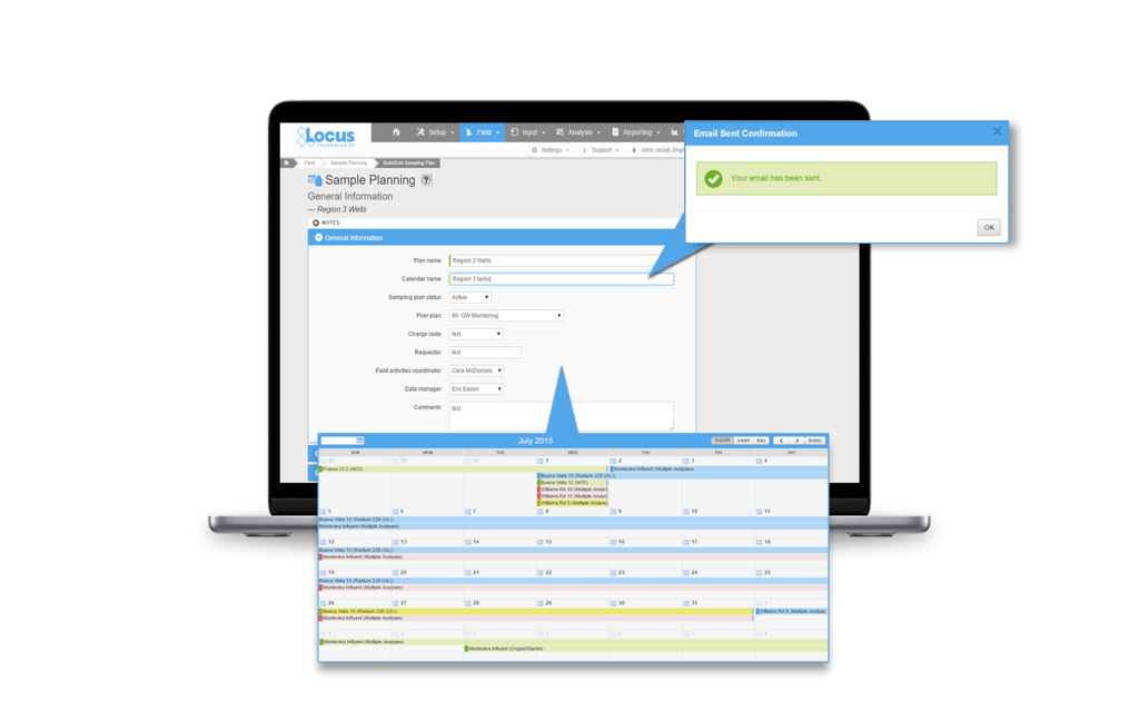
Planning tools need to allow flexibility in terms of different sampling intervals and date ranges, different field and analytical parameters, and account for location grouping. Using a well-designed application can pull together all of this detailed information and can provide a summary view of the individual samples. A manager can easily view sample status, and whether the sample is complete, in process, or planned. A well-designed application can also generate the chain of custody (COC), and lab and sample shipping date information and labels per sample, which is a huge time saver. This type of sample tracking detail seemed to be very useful to many conference attendees to help ensure they are in regulatory compliance with required sampling frequencies. A key feature to look for is an application that is flexible enough that it can allow one-time, unplanned sample events such as water main breaks, customer complaints and schedule changes, and can handle complex multi-year routine sampling with ease. As a plus, it’s easy for you or your manager to know where you stand at any time.

Data entry errors and fixing bad data when it was transcribed from field notes to Excel or other programs is a persistent problem with the old way of doing things. Your company needs a better way to streamline the error prone data collection process. Many clients are interested in an alternative to the pencil/paper/clipboard method and had goals to move to tablet or smartphone for data collection. The universal wish list for mobile field applications included:
Everyone is aware that software updates all the time. Sometimes its security enhancements and sometime feature enhancements or bug fixes. A source of frustration is getting a software update and not knowing what was updated or how best to incorporate a new feature/enhancement into their established process. There was also concern for impact to an established routine with field crews that were used to the existing way of doing things. Even if a functionality improved the workflow, enhancements are only valuable to a user if they understand how to use them and how to incorporate them into their existing process.
Mobile applications, which appear very simple to the users, are in reality complex software and require careful integration with the receiving database for a range of complex use cases. This makes rolling out new mobile features challenging for both the developers and the users. Enhanced customer/developer communication along with a sandbox environment can go a long way towards solving some of the inherent issues with rapid innovations and updates associated with cloud and mobile software.

Software tools are available and can solve a lot of the common data management challenges, but know what you want, know the problem you are trying to solve and know it will take some time and effort, but the end result will significantly improve your business processes. Though these challenges are present when choosing a software, Locus Technologies has the experts to help you hurdle the challenges to find the solution that is best for your business.
Tracking your data is made easy within our software as a service (SaaS), Locus Platform (LP). Your company can take advantage of LP’s mobile-aware browser functions, giving you the capability to do all your fieldwork with your existing phones or tablets. When cellular connections are unavailable or unreliable, Locus also has a Mobile app which supports the offline capabilities you need to keep your workflow going.
Regardless of your mobile approach, each mobile form can be easily configured to capture the data you require in the field such as photos and the sampling results.
Whether in the office, or out in the field, Locus Technologies is with you every step of the way during the tracking process. Contact us to find your solution.
![]()
There are two promising technologies that are about to change how we aggregate and manage EHS+S data: artificial intelligence (AI) and blockchain. When it comes to technology, history has consistently shown that the cost will always decrease, and its impact will increase over time. We still lack access to enough global information to allow AI to make a significant dent in global greenhouse gas (GHG) emissions by merely providing better tools for emissions management. For example, the vast majority of energy consumption is wasted on water treatment and movement. AI can help optimize both. Along the way, water quality management becomes an add-on app.
AI is a collective term for technologies that can sense their environment, think, learn, and act in response to what they’re detecting and their objectives. Possible applications include (1) Automation of routine tasks like sampling and analyses of water samples, (2) Segregation of waste disposal streams based on the waste containers content, (3) Augmentation of human decision-making, and (4) Automation of water treatment systems. AI systems can greatly aid the process of discovery – processing and analyzing vast amounts of data for the purposes of spotting and acting on patterns, skills that are difficult for humans to match. AI can be harnessed in a wide range of EHS compliance activities and situations to contribute to managing environmental impacts and climate change. Some examples of applications include permit interpretation and response to regulatory agencies, precision sampling, predicting natural attenuation of chemicals in water or air, managing sustainable supply chains, automating environmental monitoring and enforcement, and enhanced sampling and analysis based on real-time weather forecasts. Applying AI in water resource prediction, management, and monitoring can help to ameliorate the global water crisis by reducing or eliminating waste, as well as lowering costs and lessening environmental impacts. A similar analogy holds for air emissions management.
The onset of blockchain technology will have an even bigger impact. It will first liberate data and, second, it will decentralize monitoring while simultaneously centralizing emissions management. It may sound contradictory, but we need to decentralize in order to centralize management and aggregate relevant data across corporations and governmental organizations without jeopardizing anyone’s privacy. That is the power of blockchain technology. Blockchain technology will eliminate the need for costly synchronization among stakeholders: corporations, regulators, consultants, labs, and the public. What we need is secure and easy access to any data with infinite scalability. It is inevitable that blockchain technology will become more accessible with reduced infrastructure over the next few decades. My use of reduced architecture here refers to a replacement of massive centralized databases controlled by one of the big four internet companies using the hub-and-spoke model concept with a device-to-device communication with no intermediaries.
This post was originally published in Environmental Business Journal in June of 2020.
If your current water data management solution doesn’t meet these requirements, then it’s time to consider a switch.
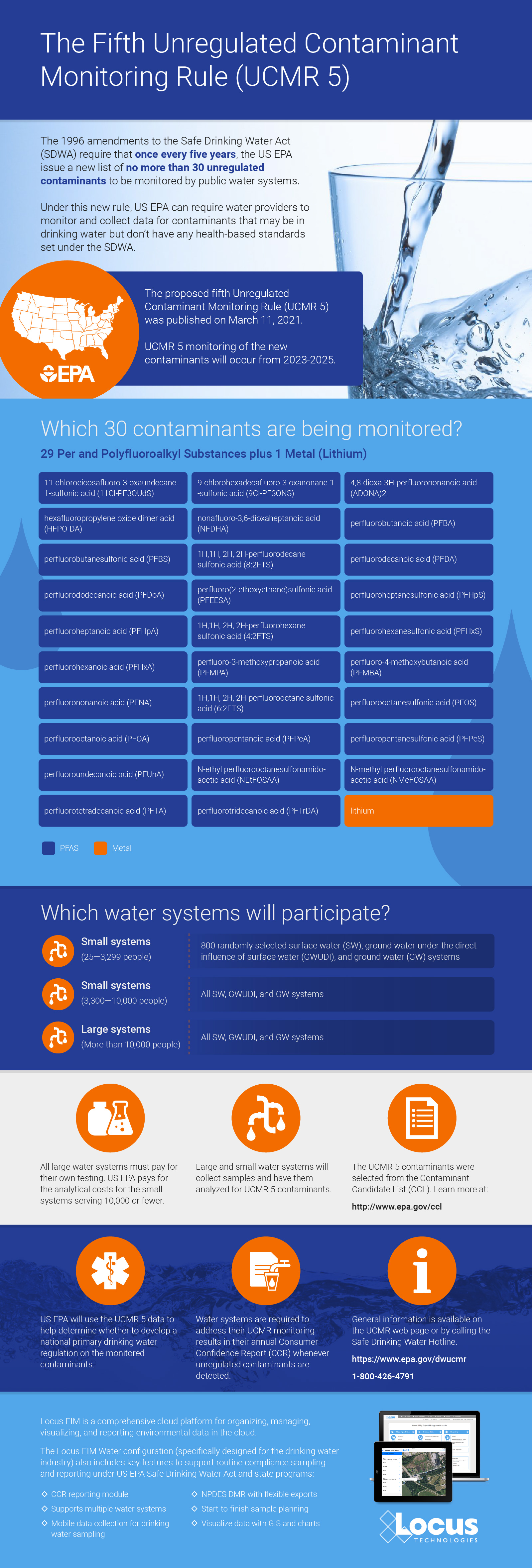
Attention all water providers: the EPA’s UCMR 5 list includes 30 contaminants (29 PFAS and lithium) that both small and large water systems have to test for and report. Can your current environmental solution handle it?
Locus EIM environmental software can handle new chemicals and analyses seamlessly. Both the standard Locus EIM configuration and the Locus EIM Water configuration (specially tailored to water utilities) are built with ever-changing regulations in mind.
We’ve put together some helpful background and tips for water providers preparing for UCMR 5 monitoring.

In 1996, Congress amended the Safe Drinking Water Act with the Unregulated Contaminant Monitoring Rule (UCMR). Under this new rule, US EPA can require water providers to monitor and collect data for contaminants that may be in drinking water but don’t have any health-based standards set (yet) under the SDWA.
More than 150,000 public water systems are subject to the SDWA regulations. US EPA, states, tribes, water systems, and the public all work together to protect the water supply from an ever-growing list of contaminants.
However, under the UCMR, US EPA is restricted to issuing a new list every five years of no more than 30 unregulated contaminants to be monitored by water providers.
This helps reduce the burden on water providers, since monitoring and testing for the existing long list of regulated contaminants already requires a significant investment of time and resources.
Throughout the course of this monitoring, US EPA can determine whether the contaminants need to be officially enforced— but this would require regulatory action, routed through the normal legislative process.
Contact your Locus Account Manager for help setting up your EIM database in advance of your sampling schedule, and we’ll make sure you’re equipped for UCMR 5!
Not yet a customer? Send us a quick note to schedule a call or a demo to find out how Locus software can completely streamline your water sampling and reporting.
More helpful links:
Sorry, no posts matched your criteria
Locus Technologies » Water Quality Data » Page 2
299 Fairchild Drive
Mountain View, CA 94043
P: +1 (650) 960-1640
F: +1 (415) 360-5889
Locus Technologies provides cloud-based environmental software and mobile solutions for EHS, sustainability management, GHG reporting, water quality management, risk management, and analytical, geologic, and ecologic environmental data management.
