By Jason Huber, Product Engineer, Locus Technologies
I had the opportunity to attend this year’s Waste Management Symposia (WM2026) in Phoenix, and through various sessions and conversations, I observed an interesting trend: extreme variance of field operation procedures from organization to organization . While many sites share similar objectives, each one has its own unique procedural requirements. That may be one reason why software from Locus Technologies was featured in the WM2026 agenda – we have a long history of collaborating with customers to develop custom programming designed to align with their specific protocols and procedures.
One such example is Newport News Nuclear BWXT-Los Alamos, LLC (N3B/Los Alamos) and their work at Los Alamos National Laboratory. The N3B/Los Alamos presenters discussed some of the unique challenges they have faced, and the enhancements Locus Technologies developed to help overcome them. This article summarizes portions of their session presentation and how the technology can assist other organizations.
Sample Planning and General Mobile Data Entry
For many customers, mobile sampling operations generally start with the Sample Planning Module within Locus Environmental Information Management (EIM) platform. Field samples, along with their associated requested analyses and field parameters (if applicable), are scheduled based on locations that need to be sampled on an individual or recurring basis. Plans can include both pre-existing locations and/or new locations that will be assigned a sampler’s geospatial coordinates in the field and added to the database after sampling.
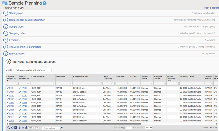
Locations, field sample IDs, and other reference values in the sampling plan are transferred to a configurable Provision File. It includes the data entry fields visible to the sampler, and the users who are assigned to the Provision. Users download Provision File(s) to their mobile device, enter data, and upload it back to EIM. A cellular or Wi-Fi connection is required to sync Provision Files to and from the device, but Locus Mobile is fully functional off-line.
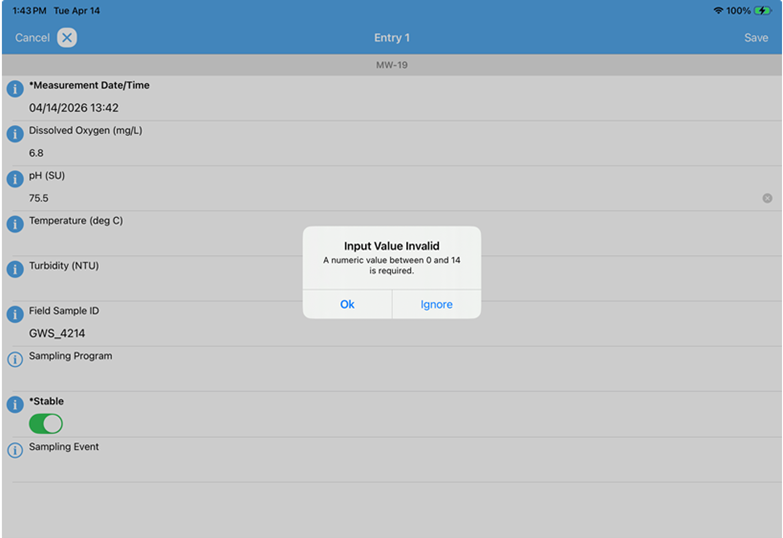
Consistency and accuracy are essential for maintaining good data, so the Locus Mobile app includes multiple safeguards to minimize mistakes. Instead of typing into a manual data entry field, the mobile user often selects from picklists of pre-existing values. This ensures that established nomenclature is respected. Locus EIM administrators can also establish valid ranges for field parameters: if a user inputs a value outside of that range, they are alerted to it.
Enhanced Groundwater Stabilization Module
In addition to the Sampling Plan, Groundwater Stabilization relies on prepopulated Well Construction information. The Locus Mobile app imports Well Depth, Casing Diameter, Drop Pipe Depth, Drop Pipe Diameter and Elevation. The user then enters a depth-to-water measurement and Locus Mobile automatically calculates Water Column Height, Drop Pipe Volume and 3 Casing Volumes (3CV). From there, the user enters the Flow Rate, and pop-up timers notify them when the Drop Pipe Purge finishes, when to take Field Measurements at regular intervals until stabilization is reached, and when the required 3CV purge is complete.
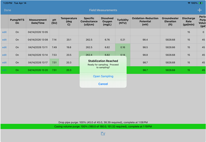
The last field readings are given a use-flag value of “Yes” to indicate that these are the reportable stable measurements. After logging field sample collection, the dataset is uploaded to Locus EIM, inserted into the database, and a Chain of Custody is printed.
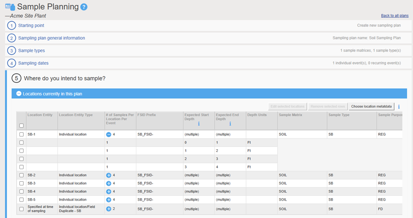
Soil Sampling Module
The Soil Sampling process begins with the Sampling Plan in Locus. Here I’ve created 5 new locations with four planned samples. Each sample corresponds to a different depth. I also added two Field Duplicate samples which will be applied to locations in the field (more on that later).
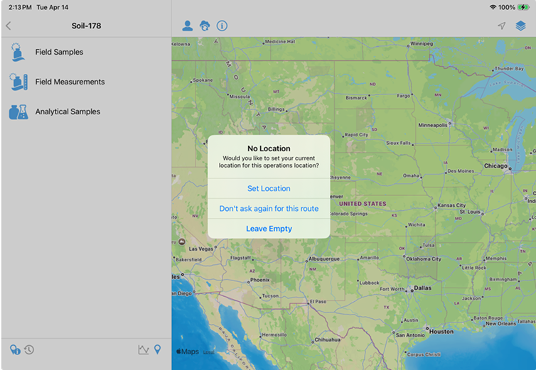
Once the field crew establishes where to take a Soil Boring, the user taps into one of the new locations and is asked if they would like to apply their current geographic coordinates to the location.
After the dataset is uploaded, users can add the new location(s) to the Locus EIM database.
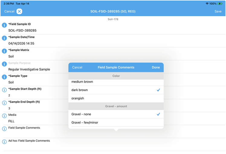
Touching on the issue of consistency, the mobile Soil Sampling module was created in part to ensure the use of established Unified Soil Classification System (USCS) nomenclature for classifications. The applicable soil descriptions can change based on the Sample Type and Horizon, so instead of navigating through one long list, or sorting through valid and invalid options, the available descriptions change based on those previously selected values. For example, I’ll get a different list for a “Soil” Sample Type in Horizon A than I would for a “Rock” Sample Type in Horizon C.
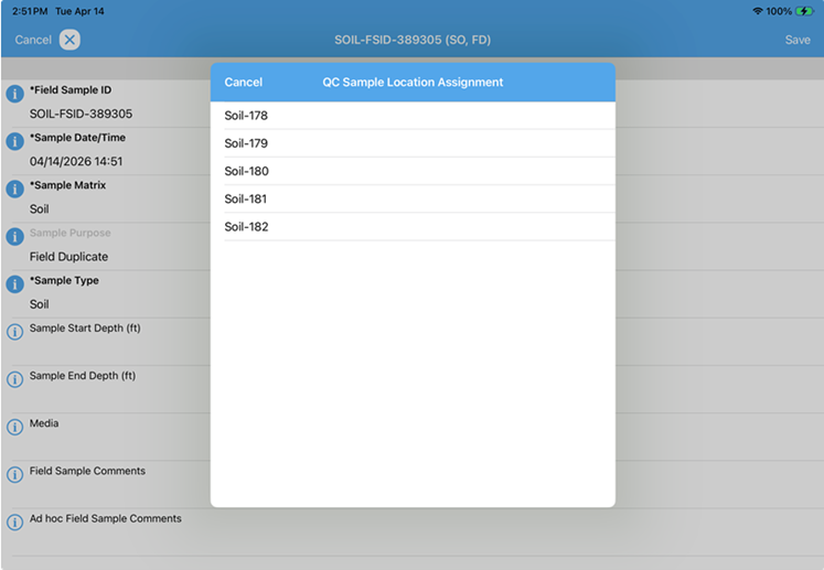
Earlier, I promised to talk about QC Samples. Because Field Duplicates, Rinsates, Blanks, etc. are often applied to sampling locations in the field, Locus EIM traditionally assigned them to a “Specified at time of sampling” virtual location and then changed to a physical location after the mobile dataset is uploaded. With the mobile Soil Sampling module , QC Samples are automatically assigned to a location via Locus Mobile app.
On upload , a report is automatically sent to specified users that includes Alpha, Beta and Mass results.
Stormwater
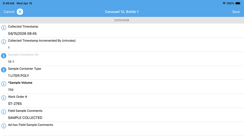
This feature within Locus EIM addresses the collection of samples from Stormwater Carousel devices that are stationed around the Los Alamos National Laboratory property in New Mexico. During a rain event, the device automatically captures surface water runoff and distributes it into a series of either 12 or 24 containers. A sampler then collects and logs each container and uploads the information to Locus EIM. From there, Field Sample IDs and analyses that were previously created in the associated Sampling Plan are assigned to each bottle.
These are just a few examples of the customized solutions Locus Technologies has developed for N3B/Los Alamos and other customers. We’ve also created specialized modules for Vapor Monitoring, Sediment Sampling and Air Monitoring, and we are continually looking for new ways to enhance Locus Mobile. For most organizations, regardless of how varied or specialized their field operations may be, the out-of-the-box capabilities of Locus Mobile provide everything needed to support efficient, reliable field execution. And for organizations with highly specific workflows, Locus’s configurable architecture makes it possible to tailor the solution to fit unique operational requirements — delivering a hand-in-glove fit that can further improve efficiency, enhance user experience, and reduce overall costs.
Locus is the only self-funded water, air, soil, biological, energy, and waste EHS software company that is still owned and managed by its founder. The brightest minds in environmental science, embodied carbon, CO2 emissions, refrigerants, and PFAS hang their hats at Locus, and they’ve helped us to become a market leader in EHS software. Every client-facing employee at Locus has an advanced degree in science or professional EHS experience, and they incubate new ideas every day – such as how machine learning, AI, blockchain, and the Internet of Things will up the ante for EHS software, ESG, and sustainability.