New spatial data analysis tools added to Locus EIM software
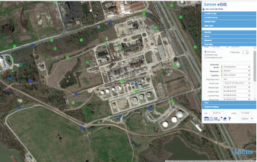
MOUNTAIN VIEW, Calif., 11 May 2015 — Locus Technologies (Locus), the leader in cloud-based environmental compliance and information management software, has announced the addition of powerful new data analysis tools to the eGIS portion of its Environmental Information Management (EIM) software. The new tools support creation of graduated color and graduated symbol legends when posting analytical results, groundwater levels, and field measurements to the map.
With the graduated color tool, when users post data to the map, they have the option to color code the map symbols by having each result placed into one color ‘bin’ based on the result value. Users can classify the results using one of four different methods: equal interval (each bin has same numerical interval with user specified number of bins); defined interval (each bin has same numerical interval with user specified interval); percent (each bin represents the Nth% of the total result range, for example quantiles or quintiles or deciles); or standard deviation (each bin represents the # of standard deviations from the mean for the result value). There are further options for specifying min and max values for the bins and for picking linear or log scales. If users are comparing results to an action limit, they can also classify results based not on the result but on the exceedance factor (result/action limit).
The graduated symbol tool works the same as the graduated color tool, except instead of color coding results, users can have the symbols change sizes based on the result. By using these new legend tools, users can create sophisticated maps that help visualize their environmental compliance data and quickly see data hotspots or outliers.
ABOUT LOCUS EIM
The Locus EIM SaaS offers enterprise environmental information management for analytical data for water quality, chemicals, radionuclides, geology and hydrogeology. EIM provides the whole solution and supports workflow from sample planning, collection, analysis, data validation, visualization and reporting. Locus Mobile is fully integrated with EIM and provides for real time field data collection and synchronization with EIM.