Tag Archive for: Groundwater

Celebrating 55 years of improving spatial thinking with GIS technology

Today, November 15, is GIS Day—an annual celebration established in 1999 to showcase the power and flexibility of geographical information systems (GIS).

Not only is GIS more powerful than ever before—it is also vastly more accessible.  Anyone with Internet access can create custom maps based on publicly available data, from real-time traffic conditions to environmental risk factors, to local shark sightings. Software developers, even those at small companies or startups, now have access to APIs for integrating advanced GIS tools and functionality into their programs.

As the Director of EIM and GIS Development at Locus, I lead efforts to integrate GIS with our software applications to deliver our customers’ spatial data using the latest GIS technology. Let us take a look at how far GIS has come since I started working with it and at some of the new and exciting possibilities on the horizon.

Origins of GIS

Before you can understand where GIS is today, it helps to know how it started out. This year is the 55th anniversary of the work done by Roger Tomlinson in 1962 with the Canada Land Inventory. We consider this the birth of GIS, and Mr. Tomlinson has been called the “father of GIS”.

The original GIS used computers and digitalization to “unlock” the data in paper maps, making it possible to combine data from multiple maps and perform spatial analyses. For example, in the image shown here from the Canada Land Inventory GIS, farms in Ontario are classified by revenue to map farm performance.
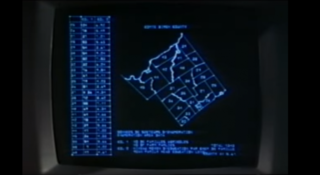
An early GIS system from the Canada Land Inventory, in Data for Decisions, 1967

An early GIS system from the Canada Land Inventory, in Data for Decisions, 1967
Photo: Mbfleming. “Data for Decisions (1967).” YouTube, 12 Aug. 2007, https://youtu.be/ryWcq7Dv4jE.
  Part 1, Part 2, Part 3

In 1969, Jack Dangermond founded Esri, which became the maker of, arguably, the world’s most popular commercial GIS software. Esri’s first commercial GIS, ARC/INFO, was released in 1982, and the simpler ArcView program followed in 1991. That year, 1991, is also the year I started working with GIS, although I used the TransCAD system from Caliper before starting with Esri software a few years later.

Back then, GIS work required expensive software packages installed on personal computers or large mainframe systems. There was no Google Maps; all map data had to be manually loaded into your software. Getting useful data into a GIS usually required extensive file manipulation and expertise in coordinate systems, projections, and geodesy.

While the government, utility, and resource management sectors used GIS heavily, there was not much consumer or personal use of GIS. As for me, I spent a lot of time in my first job digitizing paper maps by hand or trying to figure out why the map data I had loaded into a GIS was not lining up properly with an aerial photo.
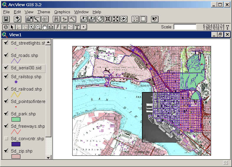
Esri’s ArcView 3.2 for desktop computers (from the 1990s)

Esri’s ArcView 3.2 for desktop computers (from the 1990s)
https://map.sdsu.edu/geog583/lecture/Unit-3.htm

The Google Revolution

How much has changed since those early days! After the release of OpenStreetMap in 2004, Google Maps and Google Earth in 2005, and Google Street View in 2007, GIS has been on an unstoppable journey—from only being used by dedicated GIS professionals on large computers in specific workplaces, to be accessible to anyone with an internet browser or a smartphone. High-quality map data and images—often the most expensive item in a GIS project in the 1990’s — are now practically free.

Just think how revolutionary it is that anyone can have instant access to detailed satellite images and road maps of almost anywhere on Earth! Not only can you perform such mundane tasks as finding the fastest route between two cities or locating your favorite coffee shop while on vacation—you can also see live traffic conditions for cities across the globe; view aerial images of countries you have never visited, and get street level views of exotic places. Back in 1991, such widespread access to free map data would have seemed like something straight out of science fiction.
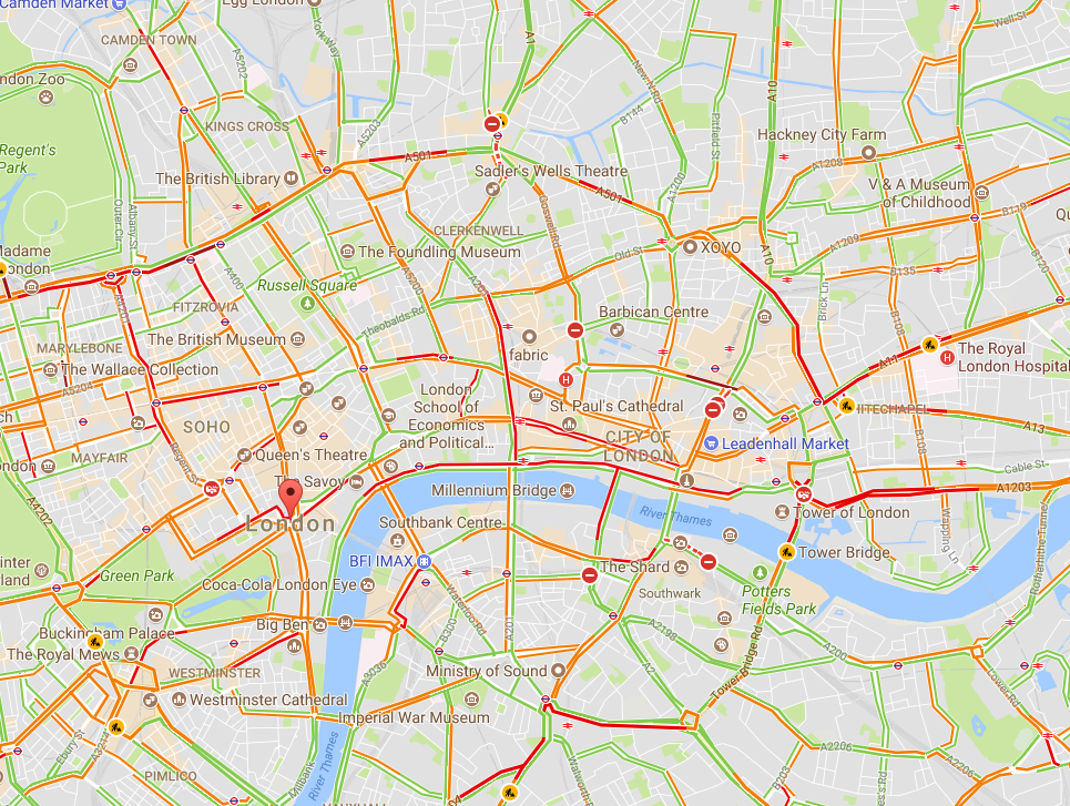
Traffic conditions in London, 3:30 pm 10/16/2017, from Google Maps
Traffic conditions in London, 3:30 pm 10/16/2017, from Google Maps

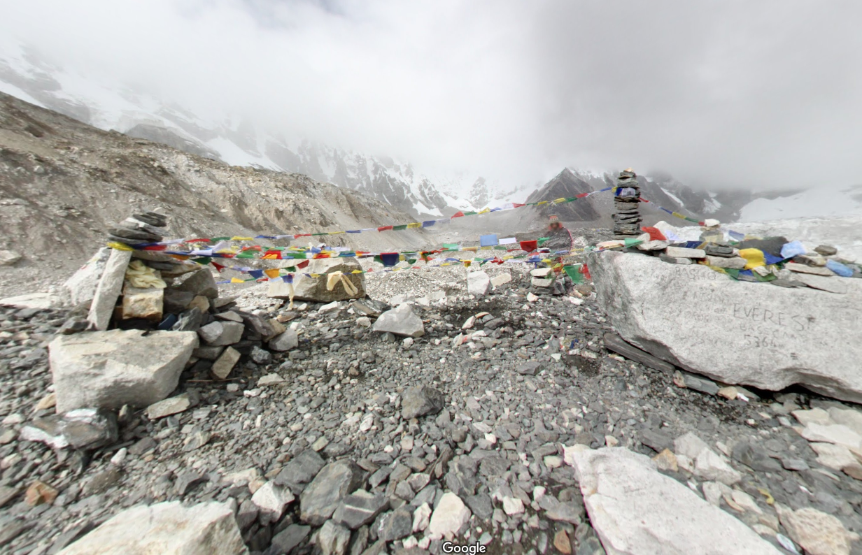
South Base Camp, Mount Everest, Google StreetView

South Base Camp, Mount Everest, Google StreetView

Mashups in the cloud

Obviously, the amount of spatial data needed to provide detailed coverage of the entire globe is far too large to be stored on one laptop or phone. Instead, the data is distributed across many servers “in the cloud.” Back in the 1990s, everything for one GIS system (data, processing engine, user interface) needed to be in the same physical place—usually one hard drive or server. Now, thanks to the internet and cloud computing, the data can be separate from the software, creating “distributed” GIS.

The combination of freely available data with distributed GIS and the power of smart phones has led us to the age of “neogeography”—in which anyone (with some technical knowledge) can contribute to online maps, or host their maps with data relevant to their personal or professional needs. GIS no longer requires expensive software or cartographical expertise; now, even casual users can create maps linking multiple data sources, all in the cloud.

Google’s MyMaps is an example of a tool for easily making your maps. Maps can range from the playful, such as locations of “Pokemon nests,” to the serious, such as wildfire conditions.
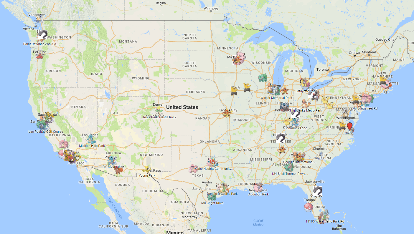
These online maps can be updated in real time (unlike paper maps) and therefore kept current with actual conditions. Such immediate response is instrumental in emergency management, where conditions can change rapidly, and both first responders and the public need access to the latest data.
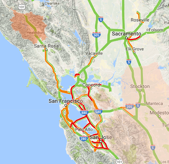
Map showing wildfire and traffic conditions in northern California, 10/16/2017

Map showing wildfire and traffic conditions in northern California, 10/16/2017
https://google.org/crisismap/us-wildfires

Furthermore, software programmers have created online GIS tools that let non-coders create their maps. These tools push the boundaries of distributed GIS even further by putting the processing engine in the cloud with the data. Only the user interface runs locally for a given user. During this period of GIS history, I created several mashups, including one for viewing natural hazard risks for my hometown. For this application, I combined several data types, including property lines, flood plains, landslide vulnerability, and wildfire risk.
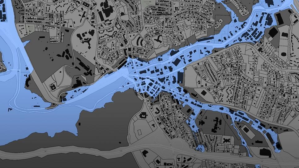
Floodplain data for Buncombe County, NC

Floodplain data for Buncombe County, NC
https://buncombe-risk-tool.nemac.org

Programming GIS with APIs

Another significant advance in GIS technology is the ability to integrate or include advanced GIS tools and features in other computer programs. Companies such as Google and Esri have provided toolkits (called APIs, or application programming interfaces) that let coders access GIS data and functions inside their programs. While neogeography shows the power of personal maps created by the untrained public, computer programmers can use APIs to create some very sophisticated online GIS tools aimed at specific professionals or the public.

During my 10 years at Locus, I have helped create several such advanced GIS tools for environmental monitoring and data management. One example is the publicly-available Intellus application that Locus Technologies developed and hosts for the US Department of Energy’s Los Alamos National Laboratory. It uses an Esri API and distributed GIS to provide access to aerial images and many decades of environmental monitoring data for the Los Alamos, NM area. Users can make maps showing chemical concentrations near their home or workplace, and they can perform powerful spatial searches (e.g., “find all samples taken within one mile of my house in the last year”). The results can be color-coded based on concentration values to identify “hot spots”.
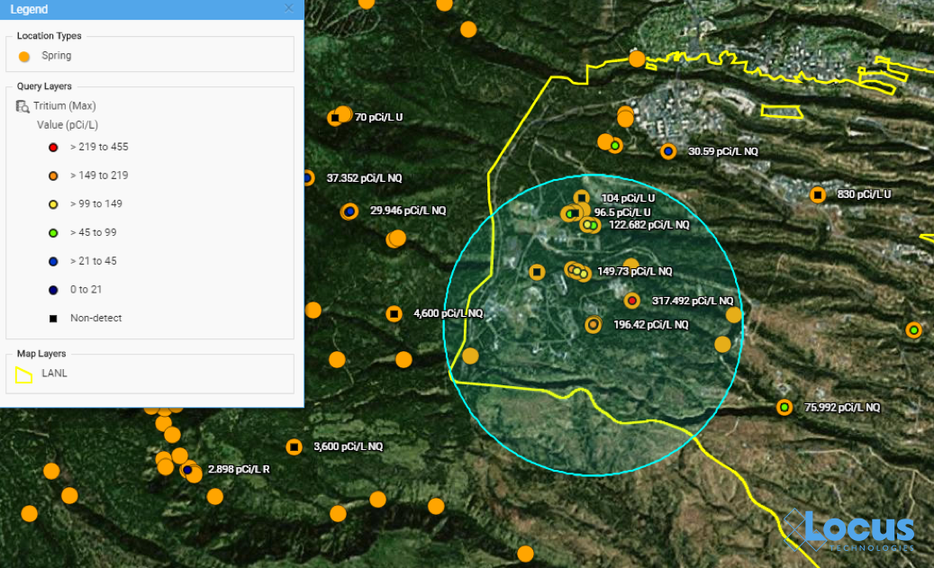
Map from Intellus showing Tritium concentrations near a specified location

Map from Intellus showing Tritium concentrations near a specified location
https://www.intellusnmdata.com

Locus Technologies also provides more sophisticated forms of analysis in its EIM cloud-based environmental management system. For example, contour lines can be generated on a map showing constant values of groundwater elevation, which is useful for determining water flow below ground. With such powerful spatial tools in the cloud, anyone at the organization, from facility managers to scientists, can easily create and share maps that provide insight into data trends and patterns at their site.
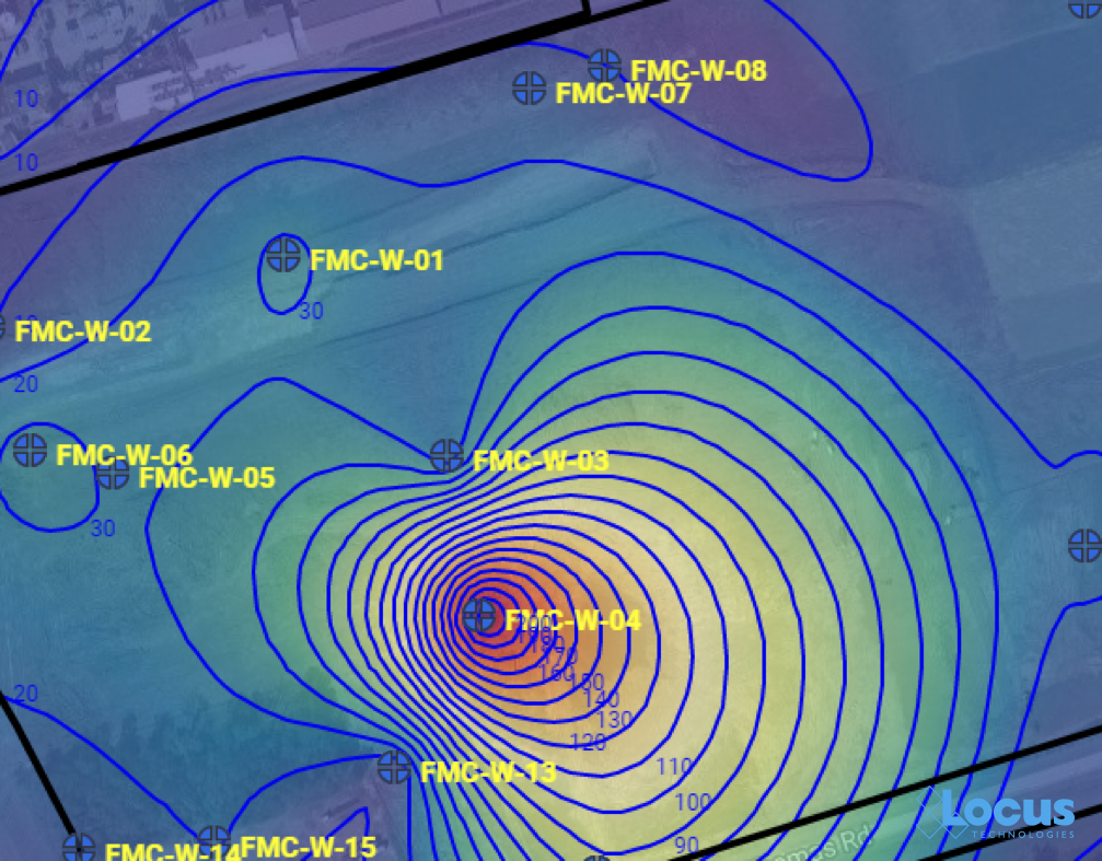
Groundwater contour map

Groundwater contour map where each line is a 10 ft. interval, from the Locus EIM system

There’s a (map) app for that

One particularly exciting aspect of GIS today is the ability to use GIS on a smartphone or tablet. The GIS APIs mentioned above usually have versions for mobile devices, as well as for browsers. Programmers have taken advantage of these mobile APIs, along with freely available map data from the cloud, to create apps that seamlessly embed maps into the user experience. By using a smartphone’s ability to pinpoint your current latitude and longitude, these apps can create personalized maps based on your actual location.

A search in the Apple AppStore for “map” returns thousands of apps with map components. Some of these apps put maps front-and-center for traditional navigation, whether by car (Waze, MapQuest, Google), public transit (New York Subway MTA Map, London Tube Map), or on foot (Runkeeper, Map My Run, AllTrails). Other apps use maps in a supporting role to allow users to find nearby places; for example, banking apps usually have a map to show branches near your current location.

What’s really exciting are the apps that allow users to enter data themselves via a map interface. For example, HealthMap’s Outbreaks Near Me not only shows reports of disease outbreaks near your location, but it also lets you enter unreported incidents. The GasBuddy app shows the latest gasoline prices and lets you enter in current prices. This “crowdsourcing” feature keeps an app up-to-date by letting its users update the map with the latest conditions as they are happening.
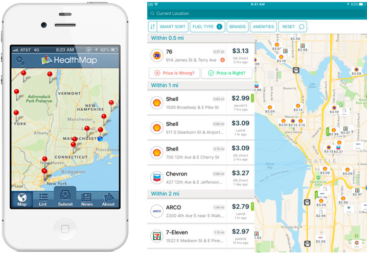
The Outbreaks Near Me app for phones (left) and the GasBuddy app for tablets (right)

The Outbreaks Near Me app for phones (left) and the GasBuddy app for tablets (right)

Here at Locus Technologies, we use the power of GIS in our Locus Mobile app for field data collection. Users can enter environmental data, such as temperature or pH measurements from a monitoring well, and upload the data back to the EIM cloud for later review and analysis. The Locus Mobile app includes a map interface for navigating to data collection points and tracking visited locations. The app also lets users create new data collection points “on the fly” simply by clicking on the map.
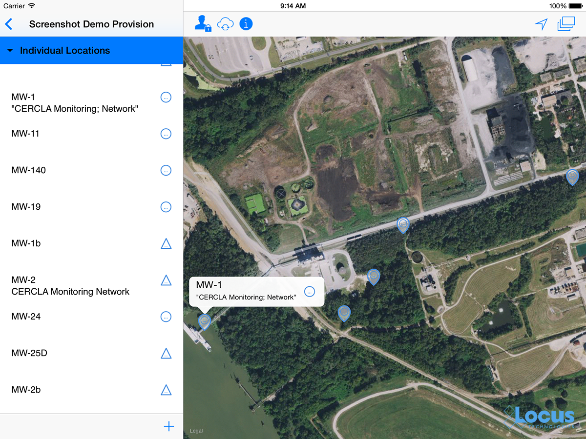
Locus Mobile map interface

The map interface in the Locus Mobile app; blue dotted circles indicate locations that are not yet started.

Looking to the future

Where will GIS go from here? It’s possible that augmented reality, virtual reality, and 3D visualization will continue to expand and become as ubiquitous as the current “2D” maps on browsers and phones. Also, the “internet of things” will surely have a GIS component because every physical “thing” can be tied to a geographical location. Similarly, GIS can play an important role in “big data” by providing the spatial framework for analysis. It will be interesting to see where GIS is when we celebrate the 20th GIS Day in 2019!

Thanks to the GIS Timeline for providing some of the history for this article.


Locus employee Todd PierceAbout guest blogger— Dr. Todd Pierce, Locus Technologies

Dr. Pierce manages a team of programmers tasked with development and implementation of Locus’ EIM application, which lets users manage their environmental data in the cloud using Software-as-a-Service technology. Dr. Pierce is also directly responsible for research and development of Locus’ GIS (geographic information systems) and visualization tools for mapping analytical and subsurface data. Dr. Pierce earned his GIS Professional (GISP) certification in 2010.


[jwplayer mediaid=”16590″]

Interested in Locus’ GIS solutions?

Introducing Locus GIS+. All the functionality you love in EIM’s classic Google Maps GIS for environmental management— now integrated with the powerful cartography, interoperability, & smart-mapping features of Esri’s ArcGIS platform!

Learn more about GIS+


California to Regulate Groundwater in 2015

California’s drought prompted the Legislature into action in 2014, leading lawmakers to regulate groundwater for the first time. The state will begin the long process of regulating groundwater for the first time in the state’s history under three new laws that require local agencies to create sustainable groundwater management plans to ensure priority basins are sustainable by 2040.

Since the state’s founding, water has been considered a property right; landowners have been able to pump as much water from the ground as they want. But increasing reliance on underground water, particularly during droughts, has led to more pumping from some basins than what is naturally being replaced.

On 16 September 2014, California Governor Jerry Brown signed three companion bills, The three bills: SB 1168, AB 1739 and SB 1319, which compose the Sustainable Groundwater Management Act (the Act) create the first comprehensive framework for regulating groundwater in California, placing managerial and monitoring responsibilities in the hands of local agencies while also creating mechanisms under which state agencies may oversee and potentially even intervene in groundwater management. With the Act to go into effect on 1 January 2015, and numerous implementation deadlines, stakeholders throughout the state should prepare for increased regulation, management, and oversight.

The Act requires the establishment of groundwater sustainability agencies (GSA) for groundwater basins in the state. By 31 January 2015, the Department of Water Resources (DWR) will classify each groundwater basin (as identified by DWR Bulletin 118) as high, medium, low or very low priority. GSAs responsible for high- and medium-priority groundwater basins must create and implement a groundwater sustainability plan (GSP) for their basins. Groundwater basins, or portions of groundwater basins, which are subject to a previous groundwater adjudication are exempt from the GSP requirement.

Once formed, GSAs will have broad groundwater management and investigatory powers to prepare and execute the GSP. GSAs may inspect property or facilities to ensure the requirements of the GSP are being met, including use of surface waters. Further, the GSA will have the authority to regulate and limit groundwater extractions, require the submission of annual extraction reports or impose well spacing requirements, among other substantial powers.

The Act requires that GSPs be designed to achieve “sustainable groundwater management” for the basin within 20 years of implementation. “Sustainable groundwater management” is defined as the maintenance of groundwater use in a manner that does not cause “undesirable results.” An undesirable result is the occurrence of at least one of the following:

  • Chronic lowering of groundwater levels, indicating a significant and unreasonable depletion of supply.
  • Significant and unreasonable reduction of groundwater storage.
  • Significant and unreasonable seawater intrusion.
  • Significant and unreasonable degradation in water quality.
  • Significant and unreasonable land subsidence that substantially interferes with surface land uses.
  • Surface water depletions that have significant and unreasonable adverse impacts on beneficial uses of the surface water.

California’s Water Shortage

A new paper published in Nature Climate Change, by NASA water scientist James Famiglietti, presents the chilling reality of California’s ongoing drought crisis. “The Global Groundwater Crisis,” uses satellite data to measure the depletion of the world’s aquifers, and summarizes the effects this has on the environment.

These aquifers contain groundwater that more than 2 billion individuals rely on as their primary source of water. Groundwater is also essential, as it is one of the main sources we rely on to irrigate food crops. In times of drought, the lack of rain and snow results in less surface water (the water that settles in lakes, streams, and rivers). Thus, farmers must rely on available groundwater to irrigate their crops, leading to rapid depletion in areas of high farming concentration.

California’s Central Valley has been one of the most effected regions in the state. The map below depicts groundwater withdrawals in California during the first three years of the state’s ongoing drought.

According to James Famiglietti, “California’s Sacramento and San Joaquin river basins have lost roughly 15 cubic kilometers of total water per year since 2011.”  That means “more water than all 38 million Californians use for domestic and municipal supplies annually—over half of which is due to groundwater pumping in the Central Valley.”

As more water is pumped from the aquifers, things can only get worse. As this trend continues, wells will have to be dug deeper, resulting in increased pumping costs. This, in turn, will lead to a higher salt contents, which inhibits crop yields and can eventually cause soil to lose productivity altogether. Over time, Famiglietti writes, “inequity issues arise because only the relatively wealthy can bear the expense of digging deeper wells, paying greater energy costs to pump groundwater from increased depths and treating the lower-quality water that is often found deeper within aquifers.” This problem is already apparent in California’s Central Valley.  Some low-income residents are forced to let their wells go dry, while many other farmers are forced to irrigate with salty water pumped from deep in the aquifer.

The lesson we can learn from Famiglietti’s research is that “Groundwater is being pumped at far greater rates than it can be naturally replenished, so that many of the largest aquifers on most continents are being mined, their precious contents never to be returned.”  This problem of diminishing groundwater is perpetuated, due the lack of forethought, regulation, or research concerning this water source. Famiglietti contends that if current trends hold, “groundwater supplies in some major aquifers will be depleted in a matter of decades.”

Without any change of practices, we can expect steeper droughts and more demand for water. Famiglietti suggests that if we ever plan on getting the situation under control, we must start carefully measuring groundwater and treat it like the precious resource that it is. However, if the globe continues on this path without any adjustment, it will most likely result in civil uprising and international violent conflict in the water-stressed regions of the world.

Water Scarcity Shines Spotlight on the Fracking Industry

The World Resources Institute (WRI) has released a report that highlights the potential for water scarcity to put a halt on fracking among the world’s top 20 shale countries.

In one of these countries—the United States—fracking has been used for years. However, new technology has enabled companies to drill deeper and horizontally, allowing fracking in more populated areas than ever before. These modern fracking techniques require millions more gallons per well of water, resulting in millions more gallons of contaminated wastewater. This increased amount of water usage results in two major causes for concern: water scarcity, and groundwater contamination.

Adding to this concern, the WRI report states that 38 percent of the world’s shale resources are found in areas that are water barren or “under high to extremely high levels of water stress”, and 40 percent of countries with the largest shale reserves have severely limited freshwater sources. With the spotlight being shined brighter than ever on fracking’s relationship with water, the WRI has compiled a list of actions for these operations to take in order to help preserve the integrity of water supplies. The list is made up of four recommendations.

First, the WRI suggests conducting water risk assessments to understand local water availability and reduce business risk. Next, increase transparency and engage with local regulators, communities, and industry to minimize uncertainty and ensure adequate water governance to guarantee the security of the water and reduce risks. The last action the WRI recommends is minimizing freshwater use and engaging in corporate water stewardship to reduce impacts on water availability.

Current findings and water shortages suggest an urgent need for improved monitoring and transparency for operations within the fracking industry. Using a centralized system for managing crucial fracking information can increase transparency, improve compliance with current regulations, and better protect the quality and quantity of the world’s water supplies.

Droughts Reinforce California’s Need for Water Management Improvements

California, also known as the Golden State, has many well-known qualities that attribute to its reputation. Many times, these qualities refer to accomplishments or physical attributes that serve as superlatives the state can claim as its own. Some examples include having the ninth largest economy in the world, and containing the highest and lowest points in the continental U.S.

Another title that California can claim is the state with the most variable climate in the U.S. – a title that also comes with some consequences.

Possibly the most significant consequence is California’s need to become resourceful with its water supply- not entirely surprising, given the drought it’s been experiencing all summer. Droughts, which unfortunately occur on a fairly frequent basis, cause the state to rely heavily on groundwater. Estimates conclude that California may rely on this source for up to 65% of its water needs.

However, California is the only state that doesn’t regulate groundwater, meaning that many of these groundwater sources are over-pumped, which can cause serious, permanent damages such as subsidence (the ground sinking), and destroyed aquifers.

What many environmental experts believe California may need is an increase on both federal and state-level regulation when it comes to water. Some suggest they should look to Australia as a model, who after their own devastating drought strongly reinforced that water is a public good, and publicly owned, in their new laws on water rights. This aggressive move toward statewide water efficiency standards is seen as a great first step, and pairs well with the need for groundwater pumping regulation, a diversified water portfolio, focus on community-based water storage, and upgraded water infrastructure, among others.

If California were to answer the call for stricter regulation on water use, it would also need a way to manage monitoring practices in order to successfully abide by these new regulations. Water quality management software is available and could potentially be a piece to the puzzle of solving the state’s water crisis.

The first bill to regulate groundwater is currently making its way through the law-making process, and only time will tell if this new water policy will set the stage for better water management techniques.

Latest version of proposed regulation changes on hydrofracking expected this week

It’s no secret that hydraulic fracturing, or hydrofracking, has been a popular topic for debate in recent years. Another occurrence revolving around this that has garnered support from some, and opposition from others, is Texas’ oil and gas regulatory agency, the Railroad Commission, updating its rules to address all aspects of the drilling process.

The latest version of the proposed rule changes is expected this week, and will be the largest revamping of Texas well construction regulations since the 1970s. These rules are important to ensure that toxic, fracking-related fluids do not leak into aquifers due to poor construction of oil and gas wells. These regulations will require examinations of things such as the quality of the protective cement placed between layers of pipe in a well, and a pressure test for the pipes themselves.

Keeping with the controversial theme around hydrofracking, some say the rule changes are too restrictive, and others say they aren’t enough. But most agree that hydrofracking does have the potential to contaminate groundwater if not performed correctly.

The contamination of groundwater can occur from faulty drilling or well completion. For the natural gas industry to ensure this doesn’t happen and to stay in compliance with these new regulations, it must keep up with an ongoing monitoring of site conditions and air emissions, management of production water, and the remediation of adverse environmental impacts: all of which involve the collection and analysis of large quantities of complex data.

Owners of hydrofracking sites and drilling companies need to take advantage of existing software tools to better organize their hydrofracking waste and water quality data. By using SaaS based software like Locus’ EIM to organize, manage, validate, visualize, store, and report this information, they can effectively demonstrate that this drilling can be done safely and transparently.

Fracking Under Fire

The Securities and Exchange Commission is asking oil and gas companies in the US to provide it with detailed information—including chemicals used and efforts to minimize environmental impact—about their use of hydrofracking.

The federal government’s investor-and-markets watchdog is stepping into the heated environmental debate surrounding hydraulic fracturing, or “fracking,” according to government and industry officials, even as state and federal environmental officials have begun to bring greater pressure on the industry. The process, which involves pumping water, chemicals and sand underground to free difficult-to-reach natural gas in shale basins, has come the center stage of political and environmental discussions.

At the same time the New Jersey Gov. Chris Christie is recommending a one-year moratorium on the hydraulic fracturing, after conditionally vetoing legislation that would have permanently banned the practice.

“Fracking” as it is often known, has provoked a fierce battle between environmentalists, who see it as a threat to public health, particularly drinking water, and natural-gas companies, which argue it is safe, and an economic windfall to …

EPA Calls for Stricter Drinking-Water Standards

The Environmental Protection Agency (EPA) is planning to tighten standards for four water contaminants that can cause cancer as part of a new strategy to toughen drinking-water regulation.

EPA said it will start rulemakings to revise standards for two contaminants used in industrial or textile processing, tetracholorethylene and trichloroethylene, within the year. The EPA will follow that rulemaking by setting stricter standards for epichlorohydrin and acrylamide, which can contaminate drinking water through the water-treatment process.
Speaking at a conference of the Association of Metropolitan Water Agencies, EPA Administrator Lisa Jackson said her agency is now developing a broad new set of strategies to strengthen public health protection from contaminants in drinking water.

“To confront emerging health threats, strained budgets and increased needs—today’s and tomorrow’s drinking water challenges—we must use the law more effectively and promote new technologies,” she said.

Ms. Jackson said the agency would now address contaminants as a group rather than individually, saying the current process is too time-consuming and fails to take advantage of cost-effective programs and technology. She said the EPA would also help to foster new technologies, use existing laws more stringently and partner with states to share data from public-water systems.

The agency is also assessing 14 other contaminants, including law and copper, chromium, fluoride, arsenic, atrazine and perchlorate.