WM Symposia 2018 provided an excellent showcase for Locus GIS+ in LANL’s Intellus website

At the annual WM Symposia, representatives from many different DOE sites and contractors gather once a year and discuss cross-cutting technologies and approaches for managing the legacy waste from the DOE complex.  This year, Locus’ customer Los Alamos National Laboratory (LANL) was the featured laboratory.  During their presentation, they discussed Locus GIS+, which powers Intellus, their public-facing environmental monitoring database website.

If you haven’t been to LANL’s Intellus website recently, you are in for a surprise!  It was recently updated to better support casual users, and it features some of the best new tools Locus has to offer.  Locus reimagined the basic query engine and created a new “Quick search” to streamline data retrieval for casual users.  The guided “Quick search” simplifies data queries by stepping you through the filter selections for data sources, locations, dates, and parameters, providing context support at each step along the way.
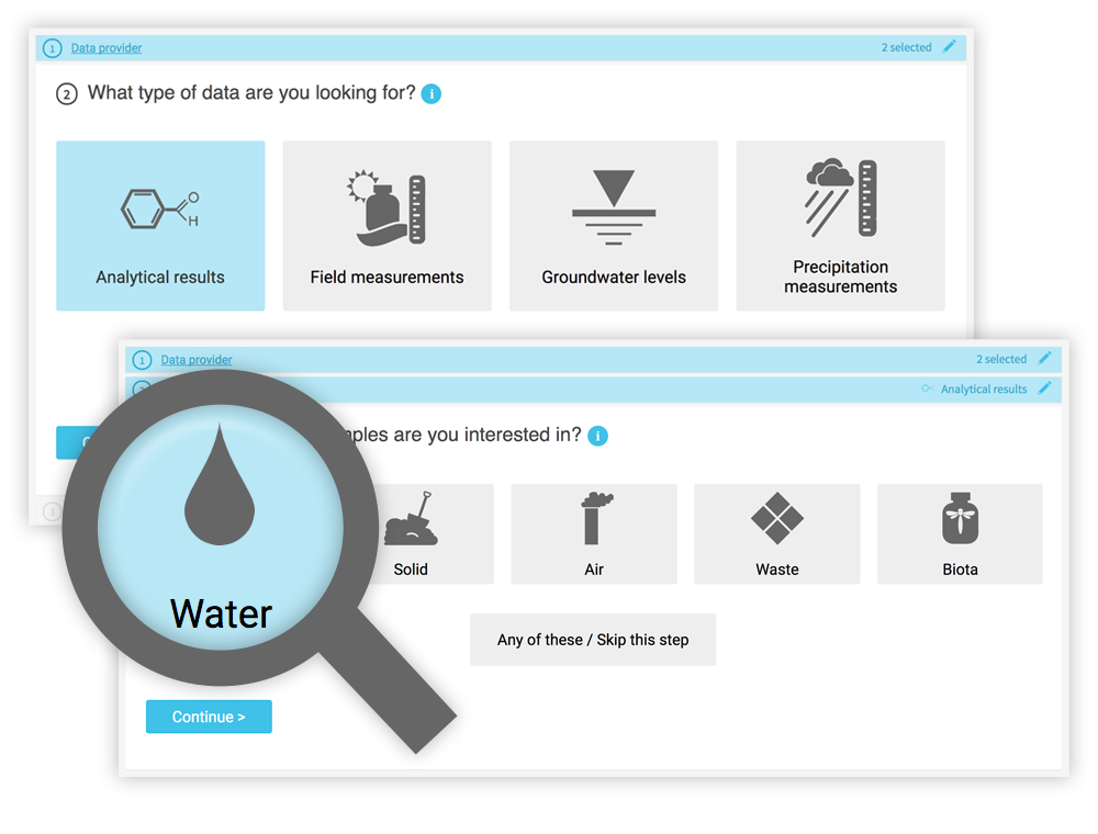
Intellus - quick searchWhile a knowledgeable environmental scientist may be able to easily navigate a highly technical system, that same operation is bound to be far more difficult for a layperson interested in what chemicals are in their water.  Constructing the right query is not as simple as looking for a chemical in water—it really matters what type of water you want to look within.  On the Intellus website (showing the environmental data from the LANL site), there are 16 different types of water (not including “water levels”).  Using the latest web technologies and our domain expertise, Locus created a much easier way to get to the data of interest.

Just querying data is not necessarily the most intuitive activity to gain insights.  Locus integrated our new GIS+ visualization engine to allow users to instantly see all the data they just queried in detailed, context-rich maps.
Intellus GIS+ Map

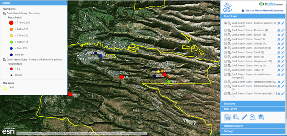
Intellus GIS+ map showing “Quick search” query results for chromium levels in the LANL area

Instead of a dense data grid, GIS+ gives users an instant visual representation of the issue, enabling them to quickly spot the source of the chemicals and review the data in the context of the environmental locations and site activities.  Most importantly for Intellus users, this type of detailed map requires no GIS expertise and is automatically created based on your query.  This directly supports Intellus’ mission to provide transparency into LANL’s environmental monitoring and sampling activities.

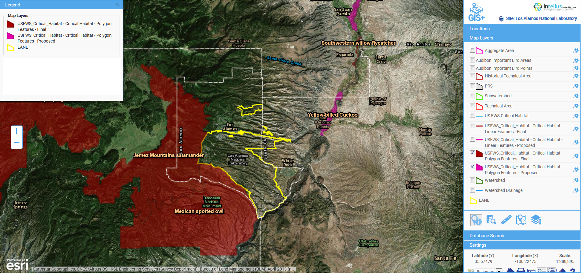
GIS+ also allows users (albeit with a bit more experience in GIS mapping) to integrate maps from a wide range of online sources to provide even more insight to the available data.  In the example below, we overlaid the publicly-available US Fish and Wildlife critical habitat maps with data from the LANL site to show the relationship of the site to critical habitats.  This type of sophisticated analysis is the future of online GIS.  Locus takes full advantage of these opportunities to visualize and integrate data from varying sources with our GIS+ tools, made simple for users and integrated with ArcGIS Online by Esri.
Intellus GIS+ Map

Intellus GIS+ map showing imported layers of US Fish and Wildlife critical habitats in relation to LANL environmental sampling data

WM 2018 - Sean and Nita

Overall, Locus is very proud of our cross-cutting environmental information management tools.  We were one of many WM18 attendees enjoying LANL’s presentation and getting even more ideas from the audience on the next steps for better environmental visualization.

[sc_button link=”https://www.locustec.com/wp-content/uploads/2018/03/WM-18-PPT.pdf” text=”View a copy of the presentation” link_target=”_blank” color=”ffffff” background_color=”52a6ea”]

Webinar: IoT technology for enhanced environmental compliance

IoT is considered one of the fastest growing trends in technology and has a potentially huge impact to automate how we manage water quality, air emissions and other key environmental performance indicators for data monitoring.

In the following webinar, we focused on how various industries can benefit from integration and interoperability of a multi-tenant cloud platform and Internet of Things (IoT) platforms for managing, organizing and monitoring the structured and unstructured data coming from various different sources. Once in the platform, a centralized data repository is created that is suitable for analyzing the key environmental indicators for management, sustainability and environmental compliance.


With the deployment of IoT through several automated technologies like sensors, programmable logic controllers (PLCs) and other internet and mobile connected devices and other instruments, a masses of real time data is generated that not only needs to be stored but analyzed and managed at interception along with several other sources of structured and unstructured data from different sources. All this data generated by different streaming devices need to be connected through a central place in a scalable cloud-based application to manage compliance and help in real time monitoring of data to come up with for effective solutions for a smarter environment management and sustainability initiatives.

Internet of Things - IoT

IoT technology for environmental monitoring is a booming industry.  The IoT growth for the water industry alone is forecasted to be  $20.10 billion by 2021 that indicates the massive volumes of data will be generated that will need to be to be monitored, managed and analyzed in intelligent, well designed software systems. Excel spreadsheets and ad hoc in-house data systems will not be up to the challenge.

What is the core business problem challenge this webinar will help the audience to solve?

IoT - Internet of ThingsMany companies are concerned that the sheer volume of data will render the information useless, unless all sources of data mentioned above can be turned into actionable information. This challenge can be addressed via the deployment of a highly scalable, end-user configurable, SaaS-based multi-tenant cloud infrastructure, coupled with environmental data management and compliance software applications.  This configuration can connect all the incoming data and create a central data repository that is easily accessible and available for use with responsive data analytics.

A multi-tenant SaaS application can help to process the flow of information in an efficient and effective manner, providing better business and information analysis and interpretation by using various integrated tools. Such applications can help in real time monitoring and provide timely alerts for management and compliance.

Coupled with business analytics, the masses of data can be turned into concise and meaningful information for system users. This approach will solve the problem of managing too much information coming into the organization, and allow it to turn the streaming data into intelligent information to support desired decision-making.

What are the top takeaways attendees can expect to learn?

  • Learn how to create a single centrally accessible system for recording data from various data monitoring sources.
  • Learn how integrating IoT technologies and a multi-tenant SaaS cloud application can allow companies to switch from periodic monitoring on a prescribed schedule to continuous real-time monitoring, without increasing monitoring cost and thereby reducing operational costs.
  • Learn how to reduce compliance cycle time and benefit from smarter management solutions.
  • Leverage the benefits of cloud computing using real-time tools like GIS applications and rich business analytics for reporting and analysis, timely alerts, etc.


[sc_button link=”https://www.locustec.com/applications/automation-sensors-iot/” text=”More on IoT” link_target=”_self” color=”#ffffff” background_color=”#52a6ea” centered=”1″]

EHS&S in the age of blockchain technology

Blockchain is a highly disruptive technology that promises to change the world as we know it, much like the World Wide Web’s impact after its introduction in 1991. As companies look to the blockchain model to perform financial transactions, trade stocks, and create open market spaces, many other industries are looking at utilizing blockchain technology to eliminate the middleman. One sector well-positioned to benefit from blockchain technology is the data-intensive Environment, Health, Safety and Sustainability (EHS&S) space.

In particular, I see three major ways that the EHS industry can utilize blockchain technology to change how they manage information: 1) Blockchain-based IoT monitoring, 2) emissions management, and 3) emissions trading.

My belief is that blockchain technology will help to quantify the impact of man-made emissions on global warming trends and provide tools to manage it. One cannot manage what one cannot measure!

Imagine this: every emissions source in your company, whether to water, air, or soil, is connected wirelessly via a sensor or another device (thing) to a blockchain ledger that stores a description of the source, its location, emission factors, etc. Every time that the source generates emissions (that is, it is on), all necessary parameters are recorded in real time. If air emissions are involved, equivalent tons of carbon are calculated and recorded in a blockchain ledger and made available to reporting and trading entities in real time.

Blockchain ledgers may exist at many levels. Some may record emissions at a given site. Others at higher levels (company, state or province, country, continent, etc.) may roll up information from lower level ledgers.

Suppose that emissions are traded so that they are not yours anymore. In that case, someone else owns them, and you do not need to report them again, but everyone knows that you were the generating source. The same logic can be applied to tier 1, 2, and 3 level emissions. Attached to the emissions ledger are all other necessary information about the asset generating those emissions, financial information, depreciation schedule, time in service, operating time, fuel consumption, operators’ names, an estimate of future emissions—the list goes on.

To learn more how blockchain technology will impact emissions monitoring, management, reporting, and trading click here.